Team Status Update 3/26/2022

This week as a group, we have primarily been focusing on two areas- learning and reflecting about engineering ethics and how it pertains to our project, as well as continuing to work on our project.

In terms of ethics, we think some of the more pertinent issues are how our traffic system could disrupt current social norms and lead to more dangerours outcomes in the long term. For example, if a crash is not detected, and people assume the automatic system would just work, they may not call the cops themselves as the status quo solution. Another pertinent issue is that of malicious surveillance as we are dealing with cameras that are used to track vehicles and other moving objects (including people).


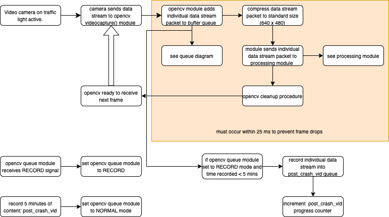
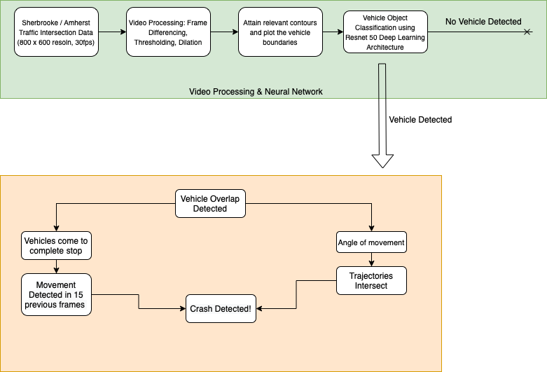
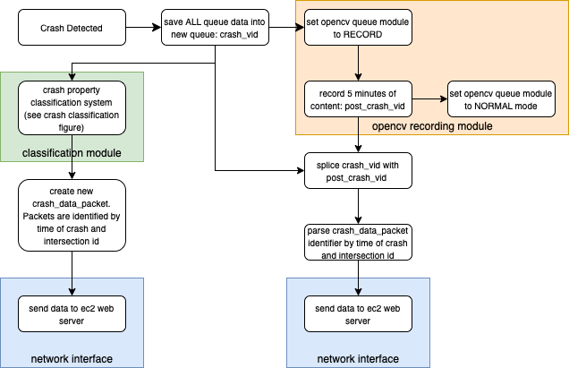
In terms of the project, we have made progress in both crash detection and rerouting, In crash detection we have been able to get outlines of the moving objects in frame, and are able to see when they overlap. We just need to keep track of the direction of movement to figure out if the vehicles are close together due to being on a collision course or they are just close together driving in two lanes in parallel directions. 


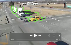
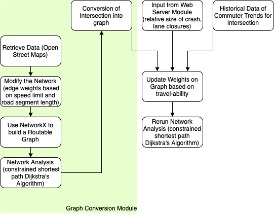
In terms of rerouting, we have a functioning system that efficiently reroutes given intersection location data. It is fully functional for up to 20 intersections. We are now also working on combining the different aspects of our project together,

Arvind status report 3/19/22

This week I’ve been thinking and brainstorming different ethics concerns of our project and how we may be able to counter it. Since we have a project that involves a camera, the main item of concern for me is the idea of a surveillance state. There is also the issue of someone with malicious intent hacking our system and rerouting traffic or specific vehicles into bad situations or causing unnecessary harm.

I think there are two simple fixes. For the issue of a surveillance state we make sure that the only part of a camera feed that is ever stored or used for further processing is the parts of the video involved with a car crash. Therefore, this is a basic prevention against using any video not involved in crash detection as it is not stored from the live feed and immediately discarded. As for the malicious intent, one easy way to safeguard against misuse is that every time any rerouting suggestion is pushed out, we re check to make sure there was in fact an improvement in traffic flow according to our traffic rerouting algorithm. If some suggestion is in fact making the situation worse or not helping, we can shut the system down immediately. Of course, this is not to say that these are very fail safe procedures or anything like that. Making our system truly secure could be a semester long task of its own, however I think this week’s focus on ethics has made us consider ethics and we have thought out some rudimentary first step ways to counter ethics issues in our system.

Jonathan’s Status Report – 3/19/2022

This week I worked more on using the contour map Arvind created to detect crashes. Currently I am using the contour map to draw rectangles around vehicles and map them on a plane to identify relative velocity / relative direction.

The current contour map we are using is essentially a pickle file where each index represents each frame. Within each index, there is are multiple arrays. Each array holds contour edges which combined create the object contour as shown below:

Notably during this integration step, we have been running into issues with our current algorithm for detecting moving vehicles. This has stalled progress on my side. For example, when multiple vehicles are in close proximity. The contours overlap and become one. This has become an issue when we tried testing our collision algorithm.

We plan to address this by exploring other algorithms for object tracking. We we still utilize the motion detecting algorithm that we have established.


Goran’s Status Report – 3/19/22

For this week our group tried to get back into the groove of work following our Design Review and spring break. Right before spring break I realized that it became necessary to fully pivot away from the Spatial Network Analysis route for rerouting. We had not really nailed down our definition of what rerouting was until now, previously I believed putting the responsibility on users to go to a specific website to get rerouting information was too placing too much faith in them, but I now realize that is necessary. Planning on using traffic lights to control traffic was both impractical and infeasible.

Now I have been making myself familiar with and using the HERE maps API, along with the React WebApp framework. Our goal is to have the rerouting information publicly available on a web server and allow for users to insert their own locations and destinations. Given an area that a traffic light has blocked off, we can make use of the routing API to find alternate paths.

Jonathan’s Status Report – 2/27/2022

Finished Recording Stream.


We are now using the python abstraction of “threads” to implement all of our modules concurrently.

I have finished implementing the signals related actions as in setting opencv queue module to RECORD when the signal is received. We copy our queue and then create a new video file in a separate thread which runs concurrently with our recording module. Then when we process a normal frame we add it to our child thread that records the video

Team Status Review 02/26/22

This week, we have been working on getting all our details for our project finalized and documented. This started with presenting and getting feedback from our design review last Tuesday. Now we have been making a few changes, particularly to rerouting, and writing them down for the paper version of the design review due next week. We have also been making progress on the different aspects of our projects’ work, such as the image and video processing, the rerouting and the video recording. We are on schedule and no updates on that end required at the moment.

Arvind Status Update 02/26/22

This week, we have mainly been working on our design review. Therefore, a lot of the work has been spent on ironing out the specifics of our project. So with regard to the image / video processing aspects of the projects, we’ve decided firmly on the data sets, the types of algorithms we wish to use on the images, and the specific type of neural net to use. I have been writing all of this down as part of the report due this week.


I have continued to experiment with the image subtraction and dilation I talked about last week. I am not getting them to work nearly as well as how it is presented in the resource I linked last time, but I’m thinking it will work well enough to be able to start tracking some vehicles. The goal for this week is certainly to get the preprocessing to a stage where I am able to track vehicles in an image by detecting movement from one image to the next.


I also want to go over feedback we got from my design review presentation in today’s meeting, especially with regard to the rerouting aspect of our project as there were a few questions about that that came up. We can use Monday’s group time and meeting with the professor to clarify.

Goran’s Status Report – 2/26/22

For this week our group worked on both our Design Review and continuing our work from the earlier week. We spent a lot of time working on detailing out specifics for our projects, which included constraints, requirements, behaviors, algorithms etc. This week I continued work on our rerouting implementation, but after going through our design review and hearing feedback, I started to think about the actual usability of our rerouting design. Right now simply using  traffic lights to control traffic does not seem to be very useful in rerouting as one it doesn’t give a lot of information and two we have no way of knowing the general path of the individual drivers. We are still thinking of ways we can include our rerouting work into our final project, so as of now I have decided to continue on this general trajectory and think about how I can fine tune it to be more useful. Below is a block diagram of our intial thoughts towards rerouting. I have also compiled a map showing travels times driving from a central location in Helsinki. This shows us how quickly one can travel in between different points of Helsinki. One way we can pivot our rerouting work is to be able to create maps showing updated travel times based on an input location and having that appear on a website, up to date with added lane closures etc.

.


Team Status Report – 2/19/22

This week our team spent a lot of time working on detailing out specifics for our project. These include constraints, requirements, behaviors, algorithms for implementation, etc. We all documented these specific details and created a set of block diagrams showing how all parts of the project (modules) interact with one another. This makes the requirements and dependencies very clear. Shown below are the four main modules.


Video Capturing Module

-Notable Implementation Updates: Most of the “normal” operations are working this week. Focus needs to be placed on RECORD signal handling.

Crash Detection / Classification Module

-Notable Implementation Updates: Moving object detection proof of concept has been demonstrated this week. Additionally we have explored deep learning architectures to use for object classification (car classification) and have settled with either resnet or mobileye.

Post Crash Detection Module

-Notable Implementation Updates: NA. Most of our efforts have been placed elsewhere. Defining constraints / requirements / behaviors is all we have put into this part of our project.

Rerouting Module

-Notable Implementation Updates: Algorithms and proof of concept have been demonstrated.

—————————————————————-

This week so far has been quite productive. We are still working in the phase in which work can be done separately. There is minimal “integration” to do at this point in our project