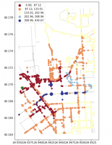
For this week our group focused our efforts on implementing the fruits of our research from last week. I attempted to make sizable strides in the rerouting department by trying my hand at spatial network analysis. I split this task into four tasks. First I retrieved the data using open street maps in python. In this example I used a small piece of Helsinki, Finland as a test. After finding this street data, I began to modify the network by adding/calculating edge weights based on travel times based on speed limits and road lengths. I then built a routable graph using NetworkX. Then I attempted work towards network analysis using Dijkstra’s algorithm to calculate times for individual cars. Below is an image of the created routable graph and an image showing nodes and their estimated traffic times.


Right now I feel as if I am on schedule, the amount of research and network analysis I have conducted this week feels like enough to continue the implementation section of our schedule. Hopefully the entire rerouting algorithm can be completed at/before the three week deadline as seen on the schedule.
By next week I hope to be able to show more reasonable progress on the rerouting algorithm, and at least have it working on a preset input of weights on one road map configuration.
