Team Status Report for 03/23/2024

Significant Risks

The most significant risk we currently face is that we have finally gotten our localization system with at least 3 anchors up and running, and yet, we are seeing less than desirable results with regards to localization frequency (not quite < 2 Hz)  and position accuracy (the tag’s distance measurements seem to have variance of up to +/- 0.75 meters). To improve the latency, we are implementing various optimization strategies such as running a thread in the background to process the data, and are already seeing slight speedup. For position accuracy, we are currently tinkering with slightly different methods of calculating the position using the 3 distances. We are also implementing smoothing that averages at least the last 3 measurements. We might also see accuracy gains if we use more anchors.

Changes to System Design

We were able to successfully set up a webserver and send localization updates to the webserver. Because of this, there was no need to make any updates to the system design. 

Schedule

This week we were able to further test the localization system. We were able to have the tag find the positions of at least five anchors simultaneously, and we also found that the maximum distance we could communicate between a tag and an anchor appeared to be approximately 35 meters, which is above the 25 meter benchmark we were aiming for in our Design Report. 

Next week is the runup to our midpoint demo; hence, we would like to continue improving our localization accuracy, augment our user orientation using the IMU data, and continue making improvements to the throughput between our webserver and the client by testing websockets. 

An updated schedule with our current progress can be found here.

Team Status Report for 03/16/2024

Significant Risks

This week we resolved the issue of forming a network with our DWM1001 development boards due to Weelie working on a multithreading task to communicate between multiple anchors. The volume of anchors a tag can communicate has not been verified yet, as we have not had the chance to test it with a larger number of anchors. We still need to find if there is an upper limit of anchors we can communicate with. Suppose we are only able to communicate with a limited number of anchors at once. In that case, we will need to tweak the tag’s routine so it initiates communication with a smaller subset of the anchors at once.

Finally, we still need to try setting up the “gateway” with the RPi4 reading from the DWM1001 board’s serial to make the RPi suitable for creating our connection to the internet. If our USB connection doesn’t work, we can try using SPI instead, which should work based on the datasheet.

Changes to System Design

This week was spent focused on the initial design of the network of ultrawideband transceivers. Our initial testing seemed positive; hence, we did not make any changes to the system design.

Schedule

This week was spent working on more of the initial setup for the DWM1001 development boards and making progress on the webapp.

We hope to spend next week working toward our midpoint demo. We would like to be able to localize our device within a room or a table, along with creating a connection to the webserver.

The following schedule includes the current progress we have made on our respective tasks.

18500 Gantt Chart 3-16

Progress

A video demo of some progress on the webapp’s “floor view” can be found here.

A video demo of progress made on the tag/anchor communication can be found here.


Jeff’s Status Report for 03/16/2024

What did I do this week?

This week I primarily worked on the web application, as well as provided some support for my teammates as they worked on the DWM1001 development boards.

For the WebApp, I focused on editing the page displaying the floorplans of the building. I changed the HTML of the page, putting the image in its container, adjusting the CSS so I could use Javascript to manually center the image in the middle of the screen over the user’s hypothetical location. Additionally, I learned how to draw lines over the image to represent the path the user should take, utilizing a canvas HTML element to draw lines, and positioning it over the image.

A short video demo can be found here.

The demo consists of mock data embedded in the Javascript. Obviously, this is not going to be useful for the final product, so I worked on creating a model to hold the position of tags on the server. Then, I added the API endpoints necessary to support updating the models (sent by the tag) and obtaining the data from the models (requests from the browser running the webapp. Overall, this was successful, and I was able to create a Python script emulating the tag, sending random positions to the server, and the positions being accurately represented in the Browser.

I briefly helped Weelie test the communication of tags with multiple anchors, which was successful due to his troubleshooting.

Is my progress on schedule?

This week I was able to make significant progress on the web application, meeting the goals I set for development of the Map view page.  However, I did not end up making progress on the A* pathfinding algorithm. This is because I opted to make more progress on next week’s task, communication between webapp and Raspberry Pi, because this task has significantly more immediate importance for our Midpoint demo milestone that is upcoming. Altogether, I believe that my progress for this week is on track.

Next week’s deliverables:

I would like to continue working on the server to ensure that communication between webapp and RPi is set up correctly. I will also need to work on running the server on AWS instead of my local machine to test the full functionality of communication.

I would like to work on a version of A* algorithm implemented, though this is still second in priority to the former task, as we are not in the stages of mapping a building floor yet.

Team Status Report for 03/09/2024

Significant Risks

This week was spent mostly working on the design review report; hence, our significant risks are still similar to those discussed in our previous report. Namely, there could be difficulties in setting up an ultrawideband network of DWM1001 boards communicating amongst each other. We need to ensure we can create this network of devices, as well as find the limit (if there is one) to the number of devices the tag can communicate with at any given time. Also, we need to make sure to set up a Gateway using a RPi. If there are issues in getting the RPi to interface with the DWM1001, we can try to use a ESP32 UWB as our gateway instead.

Changes to System Design

Our research into the design requirements whilst working on the design review report revealed that a DWM10001-Dev board paired with a RPi 4 might be a better solution using the ESP32-UWB module. This is because the RPi 4 offers significantly higher computing power that can run the localization algorithms faster, as well as any processing that needs to be done with the IMU.

We also discussed integrating sensor fusion techniques with the IMU, using a Kalman filter to decide whether to use readings from the localization network or a prediction estimate from the IMU. We think this technique could lead to an improvement in localization and are planning on continuing with it.

Schedule

This week we primarily worked on the design report. We revamped our Gantt chart to better show the work breakdown, as well as adding milestones we would like to hit.

18500 Gantt Chart breakdown

Prompt

Part A was written by Jeff, Part B was written by Ifeanyi, and Part C was written by Weelie.

Part A: Our project is named “Scotty Maps” because we wanted to create an application tailored specifically to the CMU campus. Although our web application will be specifically based around in CMU, it is not to say the project will not have a global impact. We hope to design a localization system such that it is easily adjusted to fit other buildings. By creating a localization cheaper than others, as well as well as developing tooling to help map buildings, it is entirely possible that our project can be used in a myriad of other locations, whether it still be in academic buildings, or any other commercial location in need of a navigation system.

Assuming there is widespread demand for indoor localization systems, our device could provide a massively improved quality of life for people trying to find locations in buildings by making navigation more interactive. It could affect the way navigation “assistance” is currently accomplished in buildings such as shopping malls: instead of needing to hire people to provide directions or using large monitors displaying the floorplans of the building, our product would be able to provide shoppers with a more interactive experience, showing directions and easily leading people to where they need to go.

Part B: Our project has a significant cultural impact for students across campus. This comes from the fact that students design their entire lifestyle around being on time and organized for everything that they take part in on campus. Part of these considerations involves sticking around the parts of campus that they are most familiar and can therefore navigate the most easily. This leads most students to frequent the same spots on campus for the majority of their time at the university. With our device, students can more confidently explore and traverse new parts of the campus that they are not at all familiar with. Another part of student culture is that in preparation for urgent events, such as midterm exams or finals, students have to make out time to visit the venue and learn how to get to it so that they don’t arrive late to the exam on the day. But with our device, there won’t be nearly as much of a time sink in finding a new place on campus that you’ve never been to before. Finally, students have a culture of sometimes wanting to keep to themselves. This may be for all sorts of personal reasons, such as social anxiety. With our device, they wouldn’t have to approach strangers to ask for directions to places when they get lost trying to find their way somewhere.

Part C: Our project used a lot of UWB devices to send and receive signals, and we will use wifi to transfer the location data to the web server. This may bring the concern that the signals may impact people’s health. Although UWB devices has shorter range than WIFI signals, we can get more precise location by using UWB devices than using WIFI signals. There always concerns for WIFI and  phone signals. Some people believe that the radiation will harm human bodies. However, the power of using UWB is actually lower than WIFI signals. And WIFI signals’ power is lower than an iPhone’s power.  Even iPhone’s power radiation will not do harm to humans. Thus, our devices’ radiation will not exceed the limit for human body.

Jeff’s Status Report for 03/09/2024

What did I do this week?

This week I focused my attention on working on the design review report, making sure to address several topics we had put less thought into developing, as well as responding to the feedback that was provided to us from the presentation.

Specifically, I wrote the introduction to the project, trying to better describe the motives around “why the problem is important to solve”, as suggested by feedback.

I worked on the Use Case requirements more, adding some of the ethical issues that are surrounding a location tracking device. Most use case requirements didn’t change, but I addressed feedback regarding the total system cost for installing the UWB anchors inside buildings (this cost is variable given how large a floor is, so I wrote it in terms of a “per hallway” cost).

I worked on the “ARCHITECTURE AND/OR PRINCIPLE OF OPERATION” section, which was mostly a rehash of the presentation.

For the Design Requirements section, I researched the time accuracy of the DWM1001 development boards when utilizing the TWR TOA protocol for distances. I made calculations regarding the required precision needed for our accuracy goal (which the devices meet).  From this, I also learned of the latency of communication for the devices (around 1.2 ms on successful communication). Regarding the feedback presented from the presentation, I also focused on why exactly 25 meters is a good range requirement for the ultrawideband transceivers. Again, the optimal minimum range is dependent on many factors, so I tried making clear that this requirement was likely sufficient for a typical hallway in a building.

For design trade studies, I researched other ultrawideband receivers we could use for our project. Most of these were more expensive than the DWM1001 Development board we are interested in using, so I made note of that in the report. I also improved the values in our “technology tradeoffs table”. As Professor Tamal mentioned in the presentation, we should have noted prices for installing systems. I made estimates of how much it would cost to map out a single hallway using Wi-Fi, BLE, or UWB.  I assumed it would take 3 devices to map out a single hallway (this estimate is different than mapping out an entire building, as we can overlap the devices for the hallways in a building. Looking back, I am not sure I was clear enough in elucidating this).

I also worked on the system implementation for the webapplication, developing a few mockups of some user interfaces.

Is my progress on schedule?

I was unable to make any meaningful progress on the Django webapp this week, though I was able to instead focus my efforts on planning what I want the design to look like going forward, as well as making contributions to significant portions of the design report. With this in mind, I will work on the “map view” page further next week and try to finish it after spring break.

Next week’s deliverables:

For the web application, I hope to work on the map view, implementing how I want the image frame to function, as well as working on drawing shapes on it to visualize the student’s location. Then I will get started on the shortest paths algorithm and work on visualizing it on the map.

Team Status Report for 02/24/2024

Significant Risks

This week we found we were able to successfully program the DWM1001 development boards as well as measure distances between them.

There is a risk in the fact that there could be difficulties in setting up an ultrawideband network of DWM1001 boards communicating amongst each other. We need to ensure we can create this network of devices, as well as find the limit (if there is one) to the number of devices the tag can communicate with at any given time. We would like to have these figured out next week so we know the limits of the devices relatively early on into the development cycle. If it turns out that there is a limit to the number of devices communicating, our contingencies consist of opting towards utilizing multiple UWB channels for our communication networks.

We also need to make sure that the DWM1001 boards can be connected to the internet so we can communicate data to the user. To do this, we need to make sure to set up a Gateway using a RPi. If there are issues in getting the RPi to interface with the DWM1001, we can try to use a ESP32 UWB as our gateway instead.

Changes to System Design

Because our initial progress with the development of both the web application and the DWM1001-Dev boards seemed to be overall positive, we did not make any changes to the design of the system.

Schedule

We made some slight changes to our schedule to accurately describe our tasks. Some existing tasks were reorganized.

18500 Gantt Chart 2-24

Next week’s goals:

Jeff: Continue development of the web application, making improvements to the building view to add functionality for navigation.

Weelie (also Ifeanyi): Accomplish a full “network test” this week to get unique distances from multiple devices. Is there a limit to how many devices we can talk to?

Ifeanyi (also Weelie): Put in an order form for a RPi. Then see if you can use the RPi to talk to the internet while interfacing with the DWM board. Research a good IMU (or use the one already on the DWM1001 board) to use with the RPI.

Team: work on Design Report.

Web App progress

Jeff’s Status Report for 02/24/2024

What did I do this week?

This week I spent time rehearsing the Design Presentation before delivering it on Monday.

I spent time putting together several of the views of the web application, keeping in mind the need to make it as mobile-friendly as possible.

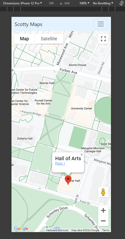
I set up a Google Maps API key so I could embed a map centered over the CMU campus, as well as working on customizing the map such that it would display fewer types of “default” pins. I followed the best case practice of utilizing a proxy on the webserver to load the map instead of including it on the client javascript to prevent unauthorized access to the API key. A header was also added, using Bootstrap to display a menu.

I worked on two models, a “Location” and a “Floor” to represent pins in the database. I added an API endpoint on the server to fetch the data for the locations, before adding client-side javascript to fetch the data using an AJAX call before creating the HTML necessary for the pins. Overall, the current map page (as viewed on a phone) looks something like this:

I also started working on another view to display the floor of the building. Current functionality allows the user to drag the image around, though I would like the image to sit in its own frame before adding javascript to move it around, and UI elements to allow the user to select a room to go to.

I worked on the Design Review Report, writing drafts of several sections such as the Use Case Requirements and Design Trade Studies.

Is my progress on schedule?

Yes, I was able to all of the Django web application tasks I wanted to accomplish this week, particularly with regards to setting up some of the main frontend pieces we need as, well as developing some models.

Next week’s deliverables:

Next week I will be working with my team to finish the Design Review Report. More research needs to be done for some of the contents, as well as a nontrivial amount of writeup.

For the web application, I hope to work on the display of the buildings. I need to work on the HTML to put the image in its own container with no overflow, along with some javascript to manipulate the position of the image.

Team Status Report for 02/17/2024

The most significant risks that could jeopardize the success of the project are difficulties in programming the DWM1001-DEV boards, as well as UWB being less robust than we initially assumed. The DWM1001 development boards use the nRF52832 microcontroller, and programming it with the functionality that we want might be more difficult due to possible lack of support in areas such as maintaining a larger network of devices or accurately calibrating for antenna delays. If these aspects seem to interfere with our project, we can either work on implementing some of the capabilities ourselves or try pivoting to using a different microcontroller with the DWM1001 boards, such as the ATMega328p, which could have more library support. Additionally, UWB could be less robust than initially assumed, providing less accurate readings indoors. The possible contingencies we are thinking of right now are to add more sensor fusion from IMUs, or in the worst case pivoting towards using a different technology altogether.


This week we finished flushing out a design of the system using UWB instead of Wi-Fi, and we were able to create an updated block diagram that more precisely reflects our understanding of the design. 


Last week we said that we were going to include a new schedule, and this week we spent some time developing it. 

18500 Gantt Chart 2-17


Goals for the next week

Put in order forms for all the all the components we want. 

Run initial testing DWM-1001 MDEK boards. Try to find distance between an anchor and a tag using to way ranging time on arrival (TOA) and make sure that it is accurate.

Continue working on setting up the webapp. 


Status Report Prompt: A was written by Ifeanyi, B was written by Jeff, and C was written by Weelie. 


Part A: With regards to health, safety and welfare, our project relieves anxiety related to being lost in unknown parts of campus. This anxiety can be especially severe when one is alone, as there would be nobody to ask for directions. And even in the presence of others, finding somebody willing to lead you all the way to a class can be hard, and time consuming, much like the alternative solution of wandering the building until the desired room is found by trial and error. In general, our project greatly aids the mental well-being of students by providing convenient access to anywhere they need to go, as well as saving students from the stress of arriving to events late by saving them time in the room-finding process.


Part B: One way our project could affect social factors is to help students navigate campus better, which could bolster or provide an incentive for students to explore campus. Some students may often feel stressed when they are tasked with going to a new building, and this device may alleviate some of the negative feelings those students may have. Our mapping software could help students save time looking for classrooms or offices, making their schedules more efficient. 

Our device could lead to privacy concerns for students, as it would consist of placing a tracking device on every student. A bad actor would be able to see the locations of students using the device. It would be important to avoid this from occurring by placing safeguards so that the privacy rights of students are respected. The device could also create dependency of students on the navigational technologies, hindering their abilities to navigate among rooms on campus without it. 


Part C: We use 12 different UWB devices for anchors, IMU and esp32 for the tag. The tag itself is not expensive, which may only take 15 dollars. However, combining with UWB devices, since each floor probably needs 12 UWB devices, for a whole building, this could be pretty expensive. For a 3 floor building, the total cost could be over 1,000 dollars. For individual users, the tag itself is easy to buy and for distribution. But for all of the anchors, it’s better for a company or the owner of the building to buy the whole system, and provide services for individual users. Since companies can also charge users for buying their services, depending on different companies, this could save their cost. For individual users, their cost will increase if they need to buy the services from companies, but it should not be as expensive as purchasing a single anchor($33). 

Jeff’s Status Report for 02/17/2024

This week I spent time researching how exactly UWB works, especially focusing on how most devices use it for calculating distances using TDOA and TOA. My findings concluded we would most likely be using TOA with Two Way Ranging to find distances.

https://link.springer.com/article/10.1007/s11277-017-4734-x

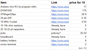
I also looked into how much it would cost to develop our own UWB tags using a DWM1000 board with an ATMega328p microcontroller.  Unfortunately or not, it appears it would be cheaper to use the preexisting DWM1001 development boards, as they are $25 apiece as opposed to at least $26.5.

I also briefly setup a Django webserver for the web application. Finally, I worked on several slides of the design presentation and created several figures for it.

My progress is overall on track for what I would have liked to accomplish this week.

Next week I will be presenting the Design presentation. Then, I will work on developing the backend of the Django webapp to include all of the models we would need for the project. I would also work on some front end templates to include a mobile-friendly version of a map.

Team Status Report for 02/10/2024

This week we spent time researching the various technologies and algorithms that could be useful in indoor localization and navigation. Overall, our findings reveal that high localization accuracy indoors might be able to be achieved in reality.

The project is still in an early planning phase, hence, we have chosen to pivot from using Wi-Fi to using UWB due to the hopes of being able to achieve higher accuracy and precision in localization. Finally, we also discussed the complexity of the project and are possibly investigating methods that could expand the scope of the project. For example, other localization techniques, such as doing computer vision on the surroundings of the user, could also accurately localize the user. Effecting such sensor fusion of UWB and CV could improve the accuracy of localization.

We are still in the midst of discussing how best to go forward and will create an updated schedule for next week.