Ayesha’s Status Report for 4/29

What did you personally accomplish this week on the project? Give files orphotos that demonstrate your progress. Prove to the reader that you put sufficienteffort into the project over the course of the week (12+ hours).

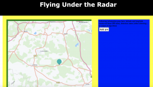
This week I worked a lot with integrating the hardware with the software. I worked with my group mates to connect the GPS to the raspberry pi, which is still giving us some issues because we were unable to get the GPS to fix. I also was able to work with linsey to get the temperature sensor reading values correctly, which we tested with an ambient thermometer and even tested at hotter temperatures with a hairdryer – pictures will be in the team status report. I was also able to run a script to get data to send from the raspberry pi to the web application and have it update within 100 ms, which is very exciting because now we can send temperature sensor data and also GPS data once that fixes. I also worked on practicing my final demo presentation a lot earlier on in the week.

Is your progress on schedule or behind? If you are behind, what actions will betaken to catch up to the project schedule?

Our progress is slightly behind because we wanted to be done integrating by the end of this week, but we are very close. In order to catch up, we are working on getting the sensor data this weekend and adjusting the web application code to accept requests that will read that data along with the GPS data. We will also finish up training since we are doing that on more data right now, and once that is done we will be able to integrate the software and test sending images through the raspberry pi.

What deliverables do you hope to complete in the next week?

Next week, along with the actual assignments that are due such as the poster, we hope to finish integrating the raspberry pi data sending to the web application, and we also hope to have integrated the software to have a fully finished product that we can focus on testing, specifically on bad network.

Ayesha’s Status Report for 4/22

What did you personally accomplish this week on the project? Give files orphotos that demonstrate your progress. Prove to the reader that you put sufficienteffort into the project over the course of the week (12+ hours).

This week I personally accomplished implementing and testing the ability to send location data to the web application and have it update and display live. This took a lot of time and debugging and testing, but I was able to successfully practice sending http requests, add the location as a pin to the map, and write a file outline to base the code for the raspberry pi on so that the data is formatted correctly. This was my goal for the week, so I am ecstatic to have accomplished it and have it working smoothly. I also worked on sending more information to the web application, like the time of the capture. Finally, I have been working on the final demonstration slides and preparing necessary materials for that.

Is your progress on schedule or behind? If you are behind, what actions will betaken to catch up to the project schedule?

My progress is on schedule.

What deliverables do you hope to complete in the next week?

In the next week, I plan to integrate the software portions of the project and also test the new temperature sensor + speaker that we ordered and make sure those are working properly. I also plan to integrate the temperature sensor with the web application through the raspberry pi.

Ayesha’s Status Report for 4/8

What did you personally accomplish this week on the project? Give files orphotos that demonstrate your progress. Prove to the reader that you put sufficienteffort into the project over the course of the week (12+ hours).

This week I personally accomplished a couple of things. First, I worked with my group members to collect radar data for training, which is explained in the team status report. This took some time for us to capture 1000 frames but it was a success. I also worked with Angie to integrate the GPS data with the web application. This is still in progress because I ran into some issues using websockets with django to receive the data, so I am currently still debugging that. Linsey and I also worked on testing the temperature sensor, but we did not have enough wire at home, so we will be meeting again in the next few days to properly test that with the arduino, but we have set up the code to run that test. Lastly, I looked into finding different views in the HERE maps api to make the pin functionality more useful, since right now the view is flat and does not provide much information to the user about what the location looks like.

Is your progress on schedule or behind? If you are behind, what actions will betaken to catch up to the project schedule?

My progress is on schedule, but I need to figure out the sockets issue and have the GPS data integrated within the next week in order to stay on schedule, so my primary focus will be collecting data and debugging the socket issue or finding a better way to implement them.

What deliverables do you hope to complete in the next week?

As mentioned above, I hope to finish integrating the GPS with the web application, and also testing the temperature sensor so that I can integrate that as well. Once I figure out the issue for the GPS, the temperature sensor should be easy to integrate with the front end since it will use the same logic. Lastly, I will collect more radar data based on how the model is doing in the training stage.

Team Status Report for 4/8

What are the most significant risks that could jeopardize the success of theproject? How are these risks being managed? What contingency plans are ready?

The most significant risks that could jeopardize the success of the project are incurring issues with training, since our dataset is not going to produce an algorithm that would work with our use case. We managed this risk by collecting ~1000 frames of our own data for training purposes, and we will continue to collect more data as the model begins training to ensure that our use case is addressed. Specifically, we will try to collect data outdoors and in fog (from fog machines), since this is what our use case aims to address. In the meanwhile, we are working on integrating the other hardware and software components, such as the temperature sensors and GPS with the frontend so that the remaining features can be ready for final integration and testing.

Were any changes made to the existing design of the system (requirements,block diagram, system spec, etc)? Why was this change necessary, what costsdoes the change incur, and how will these costs be mitigated going forward?

The most significant change, as aforementioned, was going back to the original radar we had chosen instead of the green board. Besides that, we have not made any significant changes to our system design. The costs have been mitigated by us collecting more data this week with our original radar – we collected about 1000 frames with various scenes (static, one person, one person waving arms, two people, obstructions, etc.) from various distances. Now we can speed up the training process by using this data to train the ML algorithm. Another thing we are doing to mitigate any costs is integrating other parts, like testing and integrating the GPS/IMU sensors with the web application, as well as the temperature sensors. This is so that by the time training is done, we can integrate the software portions and be done.

Now that you are entering into the verification and validation phase of your project, provide a comprehensive update on what tests you have you run or are planning to run. In particular, how will you analyze the anticipated measured results to verify your contribution to the project meets the engineering design requirements or the use case requirements?

We are planning to run tests after our model is trained by using the radar to capture live feed and comparing the accuracies of the detection to that of the previously gathered data. Since classification is not our primary concern, our entire testing plan is focused on the accuracy of the radar image human detection. Similar to how we gathered data, we will attach our radar to a swiffer to test it at various heights, and run tests on images of static scenes, humans breathing, waving arms, obstructed, interacting with other humans, and this will all be done from various distances, heights, and angles to test the doppler and azimuth axes. We will analyze these results and compare them to the anticipated measures by comparing the detection accuracy percentages, the F1 score of the algorithm, and the latency of displaying the detection results on the web application.

Ayesha’s Status Report for 4/1

What did you personally accomplish this week on the project? Give files orphotos that demonstrate your progress. Prove to the reader that you put sufficienteffort into the project over the course of the week (12+ hours).

This week I spent a lot of time reading into the REST framework to integrate the web app with the ML algorithm. I installed the framework into the web application and have been working on moving my files over to the ece machines, since that is the only place with enough storage to run the ML algorithm. Understanding how the framework would allow the two software portions to integrate took a lot of time because there was a very specific structure to follow and I had to make sure this framework would work with the model we implemented. I also worked with my team to gather data for training the ML algorithm and testing the radar image capture functionality. We met up and attached a swiffer to our radar so that we could hold it up at heights of 5ish meters, and the goal was to test the capture abilities of the radar while one of us laid on the ground and waved our arms to be detected by the Doppler shift. The radar unfortunately not connect to the computer, so we will instead meet on Sunday to redo this using the radar that is with Angie.

Is your progress on schedule or behind? If you are behind, what actions will betaken to catch up to the project schedule?

Personally, my progress is on schedule but I need to spend more time helping gather data so that I can begin integrating, because otherwise all of the parts and the integration will fall behind.

What deliverables do you hope to complete in the next week?

In the next week, I hope to gather more radar data so that the machine learning algorithm can train better. I also hope to finish integrating the ML with the web app so that the software can work cohesively. Lastly, this is a stretch goal but if all goes well with capturing data, I hope to work with Angie on getting the GPS data so that I can start working on the marker display functionality, since I have to hardcode that until I can get the input data from somewhere.

Ayesha’s Status Report for 3/25

What did you personally accomplish this week on the project? Give files orphotos that demonstrate your progress. Prove to the reader that you put sufficienteffort into the project over the course of the week (12+ hours)

This week I accomplished everything I wanted to. I integrated the HERE Maps API into my project and tested the map display and the marker addition functionalities. I spent a lot of time reading into how HERE works and how to use the different features, as well as adjusting it to the code I already had. I also implemented the zoom and scroll features on the map. Here is a picture to display the map with an example marker. In addition, I spent a lot of time adjusting the style to make sure that the map fit in the layout I had set up on the website.

Is your progress on schedule or behind? If you are behind, what actions will betaken to catch up to the project schedule?

My progress is now on schedule, which is great.


What deliverables do you hope to complete in the next week?

In the next week, I hope to integrate the web app with the ML portion so that the detection can be displayed where the blue box currently is.

Team Status Report for 3/18

What are the most significant risks that could jeopardize the success of theproject? How are these risks being managed? What contingency plans are ready?

The most significant risks that we currently have are from image capturing. This process will take the longest because there are a lot of parameters to tune with image capture, and all of the adjustments that need to be made will add some time. The risk that comes with this is delaying our integration. Specifically, we need the radar images to test our machine learning algorithm and be able to start attempting human detection. This risk is being managed by running the training and all other parts of the project in parallel with the image capture. The software components are being developed right now so that they are fully ready by the time the images are ready for training. Switching the radar is one contingency that is in place to help capture images better.


Were any changes made to the existing design of the system (requirements,block diagram, system spec, etc)? Why was this change necessary, what costsdoes the change incur, and how will these costs be mitigated going forward?

As mentioned in Angie’s status report from last week, the main change that was made to the existing design was the radar. We have switched back to the original radar since that became available from someone in CyLab that Angie had been communicating with. They left a green board for us, which was very helpful, and helped steer our design choice. Another design element that was changed was the maps API. Instead of using Google Maps API, we will be using HERE Maps API because there were too many payment issues with the Google Maps API. HERE has the same marker functionality that we wanted from Google Maps so this is still a very usable API for us. Also, it has been used by past projects so we know it is doable. The last change is that we are deploying the machine learning algorithm on EC2 instead of locally because there were space issues. There are no extra costs incurred.


Provide an updated schedule if changes have occurred.

No changes have occurred.

Ayesha’s Status Report for 3/18

What did you personally accomplish this week on the project? Give files orphotos that demonstrate your progress. Prove to the reader that you put sufficienteffort into the project over the course of the week (12+ hours)

This week I worked on four main things. I worked on the ethics assignment and evaluated different features that could be added into our project. I also communicated with many different people about how to get reimbursed for the google maps API and looked into that. This took a really long time because I had a lot of back and forth with people, and I also was later told that I could not pursue a lot of the options I was looking into. This was what I had spend majority of my time on. The third thing I worked on was looking into HERE Maps API which the professors suggested to me. After compiling a bunch of resources that could be useful for HERE, I made my free account. Throughout all of this, I also worked on making tweaks to the layout of the site. Specifically, I set up exactly what sections I would want to display map images or information so that I could have everything formatted perfectly once I start using the API and not have to waste time readjusting that.

Is your progress on schedule or behind? If you are behind, what actions will betaken to catch up to the project schedule?

I am less behind than I was last week since I was finally able to resolve the payment issues for the API. By next week, I should be able to be completely caught up by implementing the API basics and testing map functionality.

What deliverables do you hope to complete in the next week?

In the next week, I will incorporate the API and test the marker functionality. This is the main deliverable I want to complete to understand how to API works and get familiar with adding markers, since this will be the main function I have to use when I receive the GPS data.