Team Status Report for April 19th, 2025

This week, we made finished the integrating all our hardware pieces together. We have encasings for the raspberry Pi which is holding our GPS, battery, fan, and our distance sensor. We have the encasing for our wristband, which we can feel vibrations through when the sensor detects something in it’s field of view. We also decided to pivot from having a speaker + microphone attached to the raspberry Pi. Instead we are using a wireless headset which is acting as both a microphone and a listening device for the instructions. We were able to integrate this headset with the Raspberry Pi, using a bluetooth connection. After we got the encasings for all the devices we attached the connection to the gopro mount, and it is now able to be put on our bicycle for wholistic testing.

In terms of testing, we did more testing with our speech to text and our text to speech because we decided to use another speech model that was better for our bluetooth headset. This model also seemed to have more accuracy than the previous API we were using. We also tested our distance sensor to make sure it was good for detecting the motion of cars and when the user is in motion with the sensor.

RISKS:

There is potential strength of the connection piece for the mount not being strong enough to hold our device, so we need to see how it is riding quickly different terrain. There is also the risks of bluetooth connection not being the best with devices moving and every device being in encased, which could lead to choppy connection at times, but we will see with testing.

NEXT WEEK DELIVERABLES: 

Continuous testing for the device still needs to be done, testing with actual cars and different journeys. We also need to get varying user feedback on the practicality of the device. We will be working on final presentations and getting working demo videos out.

Forever’s Status Report for April 19th, 2025

WORK ACCOMPLISHED:

This week the primary focus for me was building the encasing for the device that we’re attaching to the back of the bicycle. We went through with 3D printing an initial model, but it didn’t fit all our building materials. We were planning on 3D printing another encasing for this, but we decided to move forward using acrylic as the material and using heat bending to form the case. So I made the 2D specifications for the case and laser cut the Acrylic. Acrylic was a good option since it’s durable and allows us to check into the device to ensure that everything is working properly. I also did some drilling to adjust the port positions.

Another focus of mine this week was connecting our new bluetooth device with our Raspberry Pi. In order for this to work we had to change the Google API we were using for text to speech and speech to text. I created a working script for the usage of this new API, which Akintayo was able to integrate into our navigation script. I had to change the configuration profile for our bluetooth in order for both the serial bluetooth and the bluetooth headset to work in unison.

NEW KNOWLEDGE:

When I first started this project, I had very little knowledge of the tools that would be used. The first tool I had to work to understand was the Blues kit, which was the first device we were going to use for GPS tracking / cloud information. I had to look through forums such as stack exchange, blues webpages, and youtube videos to figure out how to integrate the blues notecard with the Raspberry Pi. After we pivoted to the new GPS device there needed to be an understanding for UART connections on the Raspberry Pi, which I had to figure out through youtube videos. Then when working with the bluetooth devices, serial connections, and Arduino, I had to look through web pages , youtube videos, and webpages as well. However general knowledge such as wiring and usage of breadboards was previous knowledge learned from classes like 18-100 and 18-220.

PROGRESS:

Currently I have accomplished what was expected of me from this point, however more testing needs to be done which is what we are currently working through.

Next Week Deliverables:

Wholistic testing of the device to ensure things are moving as planned. As well as addition of additional features if things are working smoothly. We also need to finish the final poster and work on presentation slides.

Forever’s Status Report for April 12th, 2025

WORK ACCOMPLISHED:

These past two weeks I was primarily focused on integrating all of our systems together. This meant working through different options of how to have all of our programs simultaneously running on the Raspberry Pi, and how information would be shared across each of the scripts. In order to accomplish this I created a main thread script that would start three individual threads for all of our programs to run. Then I added a shared global variable which would be used for continuous updating of the current GPS longitude and latitude. This longitude and latitude would then be used by our navigation script in order to properly give users updated navigation guidance. Through this we were able to see all three of our scripts working properly together, with multiple forms of information being shared.

In addition to working on the integration, I helped reconfigure the wiring for the wristband piece, making it cleaner and connected it with the RPi. Initially we were having issues with the bluetooth connectivity, as we were trying to connect two hc-05 devices together. But I was able to find a way to pair the hc-05 with the raspberry pi via bluetooth, and have data shared between the two devices. This connection can sometimes be broken when the RPi is turned off, so I created a script that automatically runs on the RPi’s startup to ensure they are always connected in range.  I also decided to replace the arduino device for the wristband with the Blues Swan, which also has arduino pairing capabilities. The reason for this change was due to the Swan including a PMIC accessible via a JST PH connector, this allows us to power the board with a LiPo battery but also recharge the battery if need be, through the USB port. I then configured the script to receive triggers for when to vibrate from our detection device.

TESTING:

In order to meet use case requirements such as users receiving audio instructions within 200 feet of a turn, the GPS system needs to accurately measure where the user is. In order to test this, we’ve done a couple of bike trips to Phipps Conservatory and captured the longitude, latitude, and distance from turn for each of these trips to ensure the user is at the right location. Another test that has been done is putting the GPS sensor in a box, and reading GPS data while outside, to ensure that when the actual encasing is finished, we are not blocking GPS signals. Testing has been going well for this as well, but for the future we plan on testing with different locations to ensure that the GPS signal is well received in a variety of areas.

PROGRESS:

I am currently making good progress, as I’m currently testing my own subsystem and also integrating my parts with the other group members.

NEXT WEEK’S DELIVERABLES:

For next week, I’m planning on 3D printing the encasing for the Rid3 device, ensuring that it fits all our parts. I also plan on helping connect our bluetooth headset with the overall system to ensure it’s connected properly.


Forever’s Status Report for March 29th, 2025

WORK ACCOMPLISHED:

This week I was primarily focused on getting more continuous and accurate GPS data. We were able to receive an external GPS piece, called the Adafruit breakout GPS. Having an external GPS connected with our notecard allows us to simultaneously collect GPS data while keeping a cellular connection going. This can be super useful, for when we’re in areas that don’t have good wifi signal, we can depend on using the notecards cellular data to receive any API requests. It also allows us to get a more continuous stream of GPS data, which allows our location to be a bit more precise. I was also able to get the logic working that allows for our GPS to continuously run and update a file that’s being read from for our navigation system to work functionally. This connection would allow for a semi-working version of our navigation system.

PROGRESS:

I am almost done configuring the GPS portion of the navigation system,  however I haven’t gone through a lot of testing for the system. Which is where I currently should be based on our Gantt chart.

NEXT WEEK’S DELIVERABLES:

Clean up of the GPS system, testing of the system, and looking into 3D printing of our device encasing and wristband encasing.

Forever’s Status Report for March 22nd, 2025

WORK ACCOMPLISHED:

At this point in the project we’re heavily focused on working through our individual parts. I’ve been working on the navigation piece, and trying to integrate it with the Raspberry Pi. I was able to get the GPS working and i’m receiving GPS data like longitude and latitude, however the results weren’t as accurate as we wanted it to be. So we decided to move forward with triangulation as our primary method for determining where the user is, this has proved to be more accurate, however I needed to find a way to integrate their API for requesting triangulation data with our raspberry pi. That’s what I’m currently working on, as well as integrating my piece with the navigation instructions. I am still considering alternative GPS modules that could make our gps unit more precise, like the Adafruit Ultimate GPS GNSS with USB – 99 channel w/10 Hz updates.

PROGRESS:

This week I was supposed to be done thoroughly testing the GPS unit, however I’m still in this process so I’m falling behind in work.

NEXT WEEK’S DELIVERABLES:

Finish thoroughly testing GPS unit and begin integrating with navigational instructions.


Forever’s Status Report for March 15th, 2025

WORK ACCOMPLISHED:

This week my primary focus was on ensuring the GPS information was being properly read in a way that we could use it for our navigation system. I did testing in different environments inside and outside. There were a lot of issues testing, since there needs to be a stable connection that allows for the GPS information to be read properly. I noticed that the most accurate location information being shown was when triangulation was used.  I also spent time on the ethics report, and did the team discussion surrounding the assignment.

Longitude and latitude information being displayed on the notehub map.

Testing code to view location, time, and connection information

Sample output when device isn’t moving ( gps isn’t showing ).


PROGRESS:

This week I accomplished the tasks I was supposed to, so I am currently on track.

NEXT WEEK’S DELIVERABLES:

Next week I hope to clean up any loose ends with the GPS information and format it in a way to be used by our navigation system. I also plan to help integrate with the rest of our systems.

Team Status Report for March 15th, 2025

In the beginning of the week we spent time discussing the ethics assignment. Ethics is an important factor in our project, and we wanted to make sure we were all on the same page. The majority of our time this week was spent on developing the three separate areas of our project. We started off in the beginning of the week working on our object detection. We had to configure the RPi to use the RT and TX pins for the sensor.  A script was created to detect the distance between an object and the sensor. We tested this script in different scenarios, with the sensor moving as well as the object moving back and forward. However, we’re planning on testing the field of view more to see if the accuracy of the sensor is enough for our project. Towards the latter part of the week we spent time on the navigation part of the project. We spent time testing the capabilities of different models for Google Speech-to-Text AI for extracting the destination for a journey from the user’s voice commands.  We ended up choosing the Chirp 2 model, due to it’s accurate speech recognition. We also worked on the GPS tracking, as it was something we wanted to have working by this week ( see below, sample output and code ). We were able to do some testing outside and were able to receive longitude and latitude measurements to be used for our navigation system ( see below, map image capture). 

In terms of risks that we’re looking at after this week, we’re considering a couple of factors. Since we’re unable to change our distance sensors range, we believe that theres a possibility for our sensors to be detecting other objects that are outside of the range that we’re worried about. This would slow down our processing time, so we’re currently testing to ensure that this isn’t the case. Another risk we’re worried about is the accuracy of our GPS information displaying our longitude and latitude. As we were testing this week, we were seeing longitude and latitude information being sent, however depending on the mode ( triangulation or GPS location), the location being displayed wasn’t as accurate as we wanted it to be. We’re doing continuous testing to see if this is only an issue in certain areas, and are considering using a different GPS system or better antennas.

Code + Sample output for Speech to Text system

Longitude and Latitude information being sent to notehub and displayed on notehub Map.

NEXT WEEK DELIVERABLES:

Mini-integration of all of our parts to see how they work together. We’re getting to the latter end of our project, so we’re attempting a mini integration to see how they fit together, incase we need to change things up. We are also considering ordering new parts, so doing research on different types of distance sensors as-well as new GPS modules.

Team Status Report for March 8th, 2025

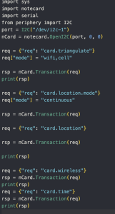
Our current progress on the Rid3 device is going well. The main tasks for this week were to complete the setup for raspberry pi, finish setup for the blues starter kit, and get basic object detection with sensors. We were able to accomplish most of these goals since our last progress report. We have the raspberry Pi set up and have made it compatible with the blues starter kit by using ssh for programming on the Pi. In addition, we worked on configuration for converting speech to text using the Google Speech API and were able to see sample outputs. We also ordered materials for a new mount for our bicycle which we designing a component that is compatible with the mount ( see below ).

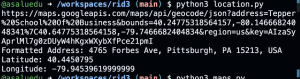
One of the risks that we are currently facing is the fact that the GPS information is not being sent properly through to the Raspberry Pi, this could be a problem as we need accurate GPS data for the proper directions to be sent.

NEXT WEEK DELIVERABLES:

Continue testing for speech-to-text translation and beginning implementation of R-Tree algorithm. Set up circuit for wristband + establishing basic object detection for sensors. Fixing GPS issues and storing GPS data to be used by the RPi.

.

component compatible with mount.

sample output for Google speech API

ADDITIONAL QUESTIONS:

Part A: … with consideration of global factors. Global factors are world-wide contexts and factors, rather than only local ones. They do not necessarily represent geographic concerns. Global factors do not need to concern every single person in the entire world. Rather, these factors affect people outside of Pittsburgh, or those who are not in an academic environment, or those who are not technologically savvy, etc.

There is a global need for increased safety and accessibility in urban mobility. Our device Rid3 can help meet this increased need for bicyclists’ safety by enhancing phone-less navigation in increasingly crowded urban settings. Bike lanes and road support for micro-mobility are being expanded in many major cities worldwide, however riders are often still at risk due to poor visibility, car blind spots, and distractions from checking navigation devices. This technology lowers the risk of accidents and increases traffic safety by enabling cyclists to receive crucial blind spot alerts and clear directions without taking their eyes off the road by fusing voice navigation with a haptic feedback wristband. This solution is particularly impactful in regions where cycling infrastructure is still developing or where road conditions are less predictable. Additionally, our device is intended to work in various climates expanding beyond what typically occurs in Pittsburgh, like high dust environments. The usability of our device is also simplistic and meant to be intuitive to promote use for all people regardless of technological expertise. By enhancing safety in diverse environments, the product contributes to broader global efforts to promote sustainable transportation, reduce urban congestion, and improve public health. A was written by Emmanuel.

Part B: … with consideration of cultural factors. Cultural factors encompass the set of beliefs, moral values, traditions, language, and laws (or rules of behavior) held in common by a nation, a community, or other defined group of people.

Within the context of our project, the main cultural factor for consideration is the fact that different countries have different road laws hence it is important that the Rid3 devices adhere to these cultural norms. Specifically, it is important that our device functions in a way that it is intuitive to a biker on the road. Consequently, it is essential that the audio feedback for navigation instructions adheres to road safety rules. Consequently, research will have to be done to ensure that the system’s feedback adheres to the rules of the region. B was written by Akintayo 

Part C : … with consideration of environmental factors. Environmental factors are concerned with the environment as it relates to living organisms and natural resources.

Environmental factors play an important role in our project. We want to make sure that we’re using resources that do not pollute the environment and are safe for the environment. It is battery powered and does not release any toxins into the air when it is running, so the environmental concerns are limited. One thing to take note of is the potential for coming across different animals in the environment. If we detect animals in our blind spot, we want to notify the user so that they don’t hit the animal coming across. C was written by Forever.

Forever’s Status Report for March 8th, 2025

WORK ACCOMPLISHED:

This week I wanted to successfully run the blues starter kit process, and collect gps longitude and latitude data. I also wanted to help program the raspberry pi to be compatible with the other devices that we are using such as the sensors and bluetooth modules. I was able to accomplish most of the tasks except for a few setbacks. I worked on making the Raspberry Pi compatible with our devices by making SSHing into the system possible, this way we could have wireless connections between the devices. I also installed a virtual view system that allows us to see what is happening on the Raspberry Pi while we’re programming on it. I also was able to install the Blues Starter Kit notecard CLI, which allows for programming with the Raspberry Pi and the notecard. I am currently able to read the GPS data being read, however for some reason the GPS kept turning off. This is something I hope to figure out by the next progress report. I

PROGRESS:

This week I accomplished the tasks I was supposed to, except I was not able to fully successfully read GPS data.

NEXT WEEK’S DELIVERABLES:

Next week I hope to fix the issue with the GPS and start working on storing that GPS information in order for it to be used for the Navigation system.

Team Status Report for February 22nd, 2025

This week we started receiving materials for our project and began testing their functionalities. We received our sensors, blues starter kit, microphone, batteries, and our raspberry pi hat. Our current risk is  stable mounting of our device to bikes. Our current implementation relied on a velcro strap which we realized after using bikes this week will be unstable.. Most bicycles use a mounting clamp to add accessories so we’ll do the same. We’re redesigning our encasing to be compatible with the NiteRider Tail Light Strap Mount. 

Since last week we decided to eliminate the web server aspect and will have all of the server processing happen on the raspberry pi. Two main reasons for this: sending audio to blues cloud is very inefficient due to the round trip latency from sending back and forward through the cloud to an internet-hosted server.  Thus not using the Blues cloud will reduce latency and it’ll be cheaper since we won’t be charged for each block of data being sent to the Raspberry Pi.

Sample Design of Encasing for Navigation/Audio System


Sample Design for Wristband  

New framework for navigation portion

NEXT WEEK DELIVERABLES:

Main tasks for upcoming week: complete setup for raspberry pi, finish setup for blues starter kit, get basic object detection with sensors.